

Overview
Quick API Reference
Explore Hyper Precise Location API endpoints
Hyper Precise Location
Advanced use cases in autonomous vehicles and IoT applications demand high-precision positioning technologies that far exceed standard GPS capabilities. Centimeter-level positioning accuracy delivers substantial performance improvements for critical applications including autonomous navigation, drone operations, and industrial automation such as robotics.
Global Navigation Satellite System (GNSS) technologies like GPS are ubiquitous in today's location-based applications. However, conventional GNSS systems provide accuracy only within three to nine meters. This imprecision stems from multiple error sources that occur between GNSS satellites and end-user devices, including satellite clock drift, orbital deviations, and atmospheric interference.
Real Time Kinematics (RTK) represents the foundational technology delivering hyper-precise location data for IoT applications requiring exceptional accuracy. RTK substantially reduces positioning errors to achieve sub-meter or centimeter-level precision across all three dimensions: horizontal (latitude & longitude) and vertical positioning. Verizon has established reference stations nationwide to deliver pinpoint accuracy to RTK-enabled IoT devices. Verizon Hyper Precise Location offers carrier-grade reliability designed to scale with Verizon's proven infrastructure.
GNSS stands for Global Navigation Satellite System and is synonymous with GPS (Global Positioning System).
RTK represents Real Time Kinematics and DGNSS stands for Differential GNSS.
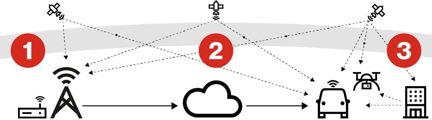
1. Verizon's RTK stations collect satellite data The nationwide RTK reference stations gather and transmit GNSS Observables to Verizon's backend infrastructure for processing.
2. Backend processes network-wide satellite data The Verizon backend analyzes and distributes GNSS correction data to field devices.
3. Corrections eliminate errors RTK-enabled devices utilize the correction data to determine their position with centimeter-level accuracy in near real-time.